GIS - Development
Land Development Applications
The Planning and Development Services Department reviews all applications for land development including site plans, subdivision and planned development approvals for compliance with the County Land Development Code (Chapter 26).
Several databases are continuously updated and used. Planning GIS uses the data to create information that can be used as planning tools for research, planning discussions with developers and citizens and may be used in applications as visual aids to promote discussions and enhance the decision making process during meetings, such as Planning Commission and Board of Zoning Appeals. Layers such as Site Plans, Minor Subdivisions, Major Subdivisions and Zoning Map Amendments have been created from information that resides in spreadsheets in the Land Development Division. The maps below are graphical representations of such data.
Map Amendment Data
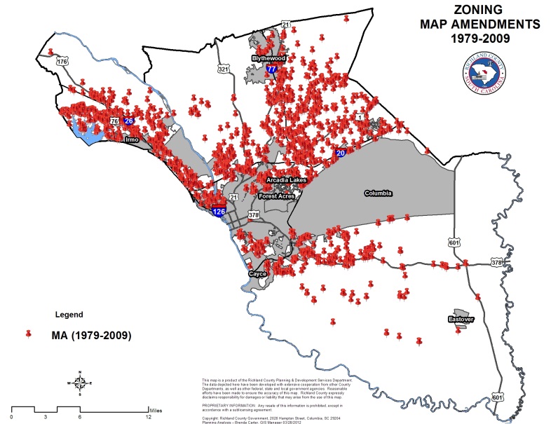
The red points on this map are actual locations of zoning map amendment cases from 1979 to 2009. The data resides in spreadsheet format however, that information has been imported into ArcGIS by Planning GIS staff and a data layer has been created. This layer can be sorted and displayed by year or any other attribute in the database. This information is for staff purposes only and not for sale.
Site Plans and Subdivisions
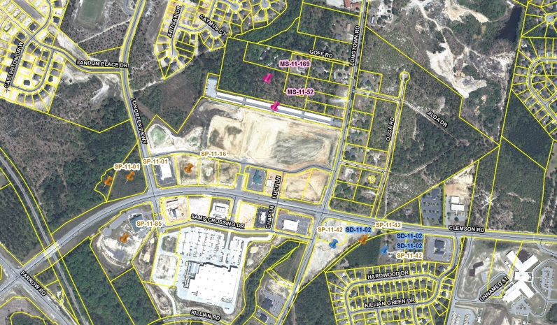
The graphic show mapped locations of minor subdivisions, major subdivisions and site plan projects that originally resided in spreadsheet format. The information became layers that can be analyzed for trends, discussions and to help to make decisions that are more informed.
These data sets were created in 2009 but can be updated at any point by simply integrating the data from 2010 to 2014.
Addressing Information
Addresses are essential to the E911 system. Addresses are vital for rapid response in an emergency. Any structure that has power, water, septic, or requires a permit should have a unique address. The GIS and Addressing Division is responsible for maintaining the E911 database, reserving subdivision and street names for use in subdivisions, naming and re-naming streets, resolving addressing conflicts, and assigning addresses in the unincorporated areas of the county. The division assigns addresses in some incorporated areas which have intergovernmental agreements with Richland County, based on the guidelines of the Addressing and Road Naming Ordinances. For more information on addressing, please email addressing.GIS@richlandcountysc.gov.
Subdivisions
An application and subdivision plans must be submitted to Development Services as a part of the Development Review Process for approval prior to the assignment of any addresses.
Addresses for Model Homes are available at the preliminary stage after approval of the plans and DXF or DWG submission. Only the model home addresses will be released.
Addresses in subdivisions will be released upon request after completion of first review of the bonded plat digital file. The addresses will be provided in an excel spreadsheet. The digital file must include the following:
- Closed parcels
- Correct street names
- Correct lot numbers
- Correct centerlines
Please give ample time for the process to be completed and make all subdivision address requests to Betty Etheredge at etheredge.betty@richlandcountysc.gov.
Site Built and Modular Homes
Individual site built or modular homes, which are not in subdivisions, may be addressed on a walk in basis. Addresses must be assigned before a well and septic tank permit can be obtained from DHEC.
Business, Commercial and Industrial Structures
An application and site plans must be submitted to Development Services as part of a review process. During the review process the plans will be sent to GIS and Addressing for review and address assignment.
Utilities
Addresses are assigned for various utilities in the county. Some utilities such as cell towers, lift stations, radio towers, and water tanks, must submit an application and site plan to Development Services for the review process. Other utilities in the county that require an address are power poles, telephone boxes, and cable boxes.
Other
Other structures in the county subject to address assignment are: signs, billboards, and commercial fountains. These structures require Development Services approval prior to obtaining an address assignment.
Why Digital Data Submissions? (DXF/DWG)
Richland County has adopted geographic information systems (GIS) technologies to store, manage, and maintain spatially-related (geographic) data. The land development, engineering, and surveying communities have also embraced digital technologies in their respective professional communities. Because development plans are now created using computer aided design and drafting (CAD), it is the goal of Richland County to leverage such advanced techniques to expedite the design and plan review processes within the County. For such an effort to succeed, standards must be implemented to allow CAD data to be integrated into the County GIS while preserving the referential and positional accuracy of the original measurements.
All developments are required to submit preliminary (proposed) and as-built (plan of record) digital plans in accordance with the standards outlined below. Proposed digital submissions (DXF or DWG’s) must be accepted by the Planning Department GIS staff by the last business day of the month to be placed on the following months Planning Commission Agenda. Three business days are required to review each digital submittal package to ensure that it meets the digital data submission standards (example: submitted by developer on August 25, 2004, accepted by Planning GIS Staff on August 30, 2004, placed on October 4, 2004 Planning Commission Agenda). Similarly, digital as-builts (plan of record) in accordance with the standards outlined below must be accepted by Planning Department GIS staff prior to the scheduling of the final inspection and prior to the transferal of right-of-way maintenance duties. For commercial developments, a digital 'as-built' submission must be accepted by Planning Department GIS staff prior to the issuance of a certificate of occupancy.
These data submission standards are intended to improve the process of reviewing plans and help maintain a digital database of geographic information for the County. As the GIS program develops and foundation data are established, the County will be able to offer base layers to the development and engineering communities. The County understands that these GIS layers cannot be used for construction; however, the multiple layers of data are expected to provide potential users with descriptive information that will be invaluable in planning and property valuation.
Digital Data Submission Standards